Construction projects in the AEC industry often suffer from disconnected field data, outdated drawings, and mismatches between design intent and site conditions. These gaps frequently cause layout errors, delays in trade sequencing, and high volumes of rework. Teams rely on fragmented documentation, which slows down coordination between contractors, consultants, and site crews. As construction schedules tighten and the use of prefabricated systems increases, the risk of field clashes and installation setbacks grows.
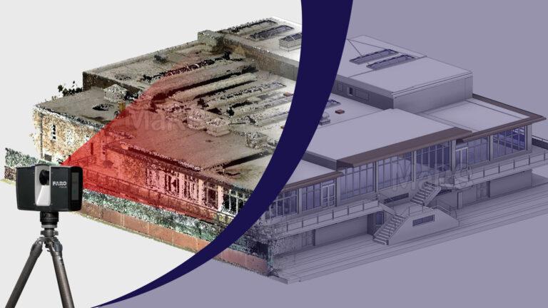
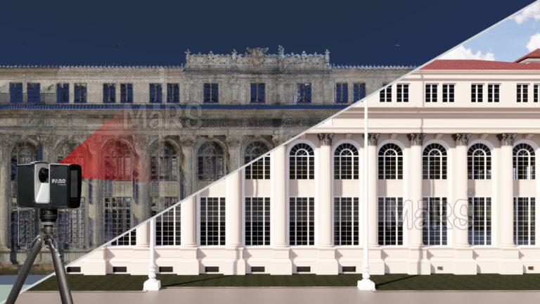
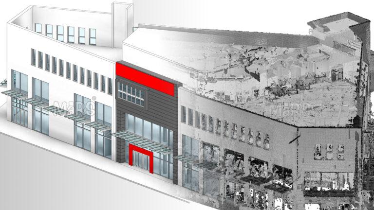
These services offer a field-driven method to document actual site conditions with high spatial accuracy. Using terrestrial laser scanning or drone-based LiDAR, project teams can capture detailed 3D data of structural elements, utilities, and surrounding environments. This data supports more reliable model validation, trade coordination, and quality control throughout the construction lifecycle. By integrating Point Cloud to BIM Services, teams can efficiently convert raw scanned data into intelligent, editable BIM models. From pre-pour verification and MEP layout validation to progress tracking and post-installation records, It introduce a workflow that reduces reliance on manual checks and guesswork.
What Are Point Cloud Services?
Point cloud services generate precise, high-density 3D datasets that replicate real-world site conditions. Using terrestrial laser scanning, drone-mounted LiDAR, or handheld scanners, construction teams can capture millions of spatial data points across slabs, MEP zones, structural cores, and exterior façades. This detailed scan data creates a digital field record that reflects actual geometry, which is important for layout checks, elevation validation, and installation planning during active construction.
When integrated with BIM and coordination models, mesh data become a reliable tool for aligning trades, verifying built conditions, and planning sequencing. Construction managers and subcontractors use these datasets to overlay on design models, identify tolerances, validate dimensions for prefabricated assemblies, and track on-site progress. The result is greater certainty in decision-making, improved accuracy in execution, and fewer disruptions during critical path activities.
Key Benefits and Efficiency Gains in AEC Projects
Accurate As-Built Documentation
Site teams often start work based on outdated architectural drawings or inconsistent field measurements. A point cloud scan taken before mobilization gives the construction manager and BIM lead a verified digital reference of structural cores, levels, and slab edges important for accurate grid layout, structural framing, and early trade coordination in live or constrained sites.
Eliminating Rework in MEP Installation
Before fabrication begins, MEP contractors overlay coordinated BIM with field-scanned point clouds to ensure wall penetrations, soffit zones, and service corridors are truly constructible. This step prevents forced rerouting or on-site modifications, which typically delay installation and force material wastage and scheduling conflicts. On a recent Corporate Building Scan to BIM in Georgia project, early clash detection between chilled water lines and structural beams using scan-based validation eliminated an entire round of rework across three floors saving both time and subcontractor cost exposure.
Concrete Pour Planning
When scanning the deck after rebar placement but before pour, superintendents can verify that conduit sleeves, box-outs, and inserts match shop drawings and BIM layouts. This pre-pour check confirms anchor points align with future steel or equipment loads, reducing the risk of misalignment and post-pour drilling.
Installation Tolerance Verification for Prefabricated Systems
Fabricated riser shafts, pump skids, or corridor modules must match tight vertical or horizontal tolerances. Scanning the intended install zone beforehand gives prefab teams real-time spatial input, allowing adjustment before delivery. This avoids on-site downtime due to dimensional conflicts and keeps crane picks on schedule.
Capturing Hidden Services Before Closure
Before drywall closure or ceiling tile installation, data capture in-wall plumbing, conduit runs, fire-rated sleeves, and cable trays. These models are indexed by location, allowing facility teams and future contractors to access accurate service paths during maintenance, minimizing wall cuts or exploratory demolition.
Rapid Validation of Subcontractor Work
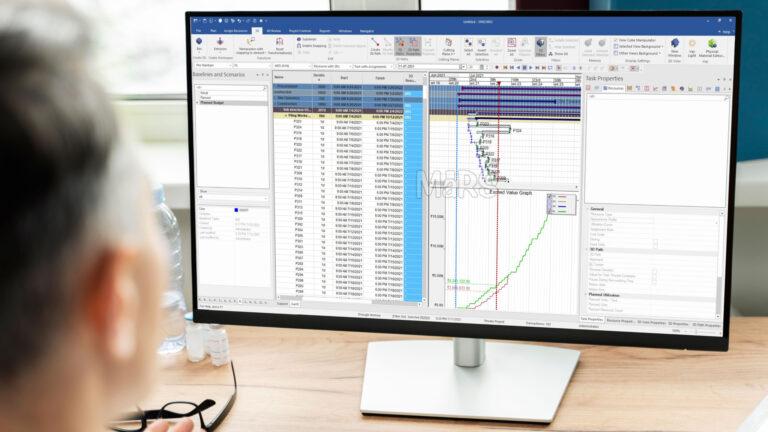
Daily or weekly scans during critical path activities like façade install, and HVAC zones are compared with coordination models to validate geometry and progress. This allows project engineers to document completed quantities tied to earned value, speeding up subcontractor billing approvals and reducing friction in payment cycles.
Change Order Justification with As-Built Comparison
When discrepancies arise between field conditions and design, scan data provides quantifiable proof for deviation. For example, if a structural beam is misaligned by 40 mm from plan, point cloud overlays enable contractors to document impact, recalibrate MEP routing, and submit data-backed change requests to the consultant or client.
Accelerated Handover with Digital Twin Integration
At project closeout, the final site scan becomes the geometry foundation for asset-tagged digital twins. Mechanical rooms, risers, and accessible ceilings are linked with serial numbers and commissioning data, giving the FM team a true-to-site visual model with spatial intelligence for preventive maintenance and long-term operations.
Improved Design and Coordination
Design changes during construction often overlook actual field constraints. By scanning partially completed zones like stairwells, lift shafts, or core walls. BIM managers can re-coordinate steel embeds, MEP sleeves, and finishes with real geometry, preventing downstream conflicts and trade delays during critical installation phases.
Faster Project Delivery with Scan-to-BIM
On renovation or adaptive reuse projects, traditional measurement takes weeks. With a point cloud scan captured in 1–2 days, the design team can model from exact geometry of existing walls, window openings, and floor slopes, reducing modeling time and accelerating permit, procurement, and shop drawing phases.
Construction Monitoring and QA/QC
Scans taken during install phases like post-duct drop, before ceiling closure to help QA/QC engineers validate alignment, invert levels, and hanger positions against coordination models. This helps identify trade deviations immediately, issue corrective actions, and maintain accountability across subcontractor scopes.
Detailed Prefabrication and Modular Assembly
For projects using modular MEP corridors or bathroom pods, exact slab-to-slab heights, wall offsets, and sleeve positions are scanned before units arrive. Prefab vendors use this geometry to build with tolerance-specific accuracy, ensuring the modules slide into place without cutting or site-based patching.
Renovation and Retrofitting
Older buildings often have undocumented structural additions or modified utility paths. Scanning exposed MEP and structural zones during selective demolition gives architects and engineers immediate visibility into constraints allowing phased retrofit planning with clearances, clash avoidance, and selective modeling where needed.
Improved Safety and Regulatory Compliance
Scans of high-traffic or overhead install zones help EHS officers identify clearance violations or unsafe access routes. Safety teams use 3D data to verify working platform heights, confirm fall protection anchorage layouts, and validate compliance with local spacing and egress codes.
Key Metrics Improved by Point Cloud Services
- Rebar and embed placement errors reduced by 80–90% on poured slabs due to pre-pour scanning and overlay with structural drawings
- Trade misalignment issues dropped by 70% in riser shafts and ceiling zones when scanned before and after MEP installation
- Installation rework costs cut by up to ₹4–6 lakh per zone on modular corridors due to tolerance verification scans before delivery
- Subcontractor billing approval time shortened from 14 days to 3–5 days by using scan data as measurable proof of completed scope
- Concrete pour hold-ups avoided on 100% of verified decks where slab scanning confirmed correct box-outs, sleeves, and anchor locations
- 3–4 weeks saved on renovation projects by generating Scan-to-BIM models of legacy buildings within 3–5 working days
- MEP hanger layout errors reduced by 60–75% through laser scan validation before ceiling closure
- Field QA inspections executed 2x faster by overlaying point clouds with coordination models for automated dimensional checks
- Digital twin readiness achieved within 7–10 days post-handover using final scan data instead of manual as-built redlines
- Prefabrication rejections dropped below 3% when scanned install zones were used as fabrication inputs
- On-site punch list issues reduced by 50% in zones where progressive scanning was used during interior fit-out
- Scan-to-approval time for change orders cut by 5–7 business days, supported by measurable deviation analysis
- Site access planning improved with 100% clearance compliance in scanned logistics zones for scaffolding and lift installations
- Reduction of 25–30 site hours per week previously spent on manual measurement and cross-verification by layout teams
Conclusion
Construction teams across the AEC industry are increasingly using scanned information to improve accuracy, reduce delays, and strengthen project control. From verifying slab layouts before concrete placement to ensuring prefabricated systems fit within actual field tolerances, laser scan data supports task-level decisions that affect daily productivity. Contractors use point cloud workflows to validate geometry, reduce clashes, streamline billing, and create reliable records for handover. AEC firms gain tighter control over quality, sequencing, and progress tracking. This results in more predictable schedules, lower rework rates, and better alignment across stakeholders from site teams to facility managers.