Scan to Plan 2D AutoCAD Drawing Services from As-Built Conditions

MaRS Trans USA offers a variety of accurate Point Cloud to 2D CAD Drawing services globally. This includes detailed architectural, structural, and MEP drawings for all types of projects.

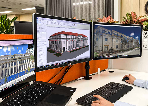
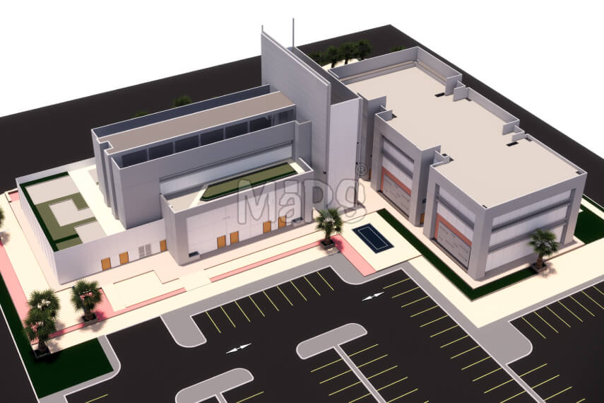
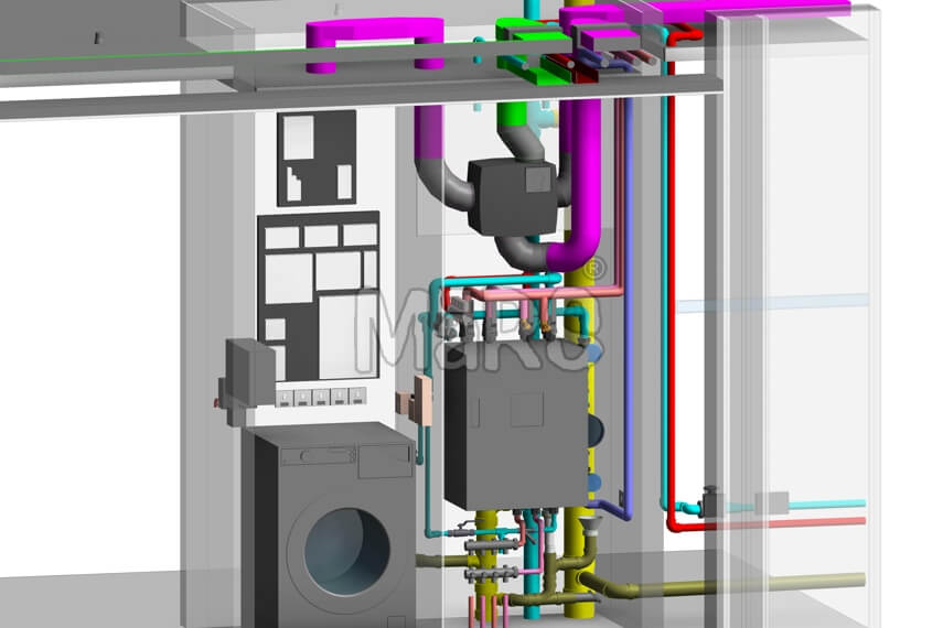
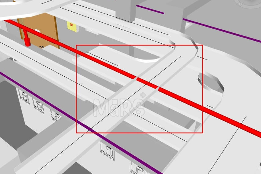
MaRS Trans USA provides a Point Cloud to 2D CAD Drawings services globally, specializing in converting complex point cloud data into precise and functional 2D CAD models. Our services cover a wide variety of industries, ensuring accurate drawings for the AEC projects.

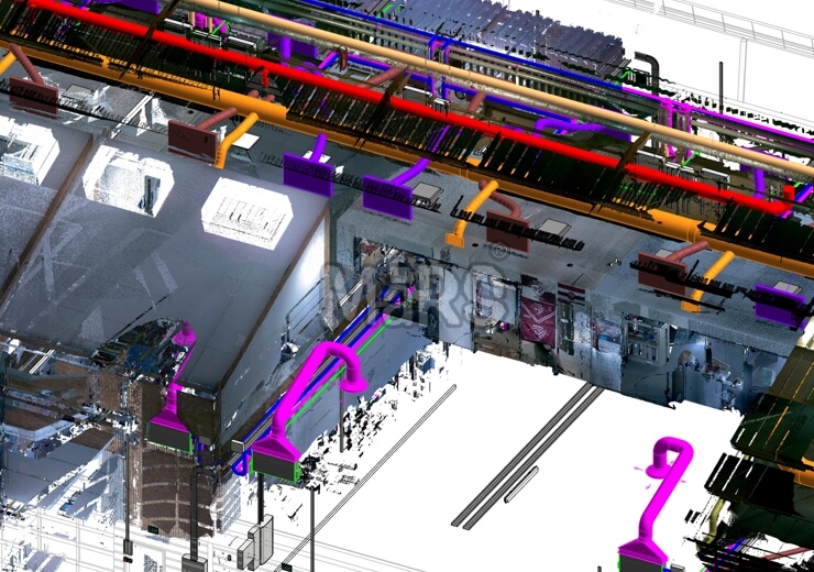
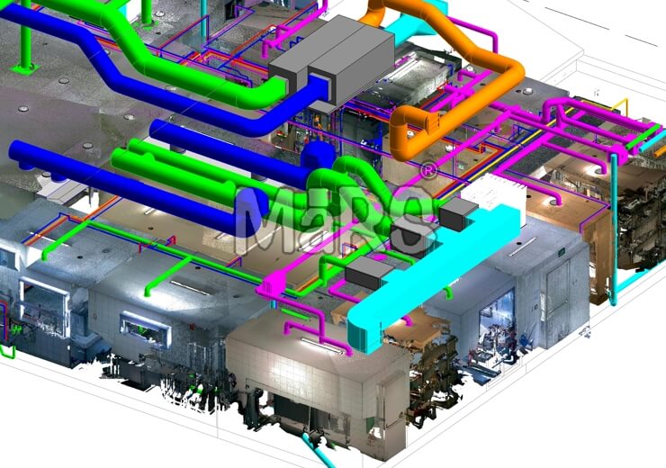
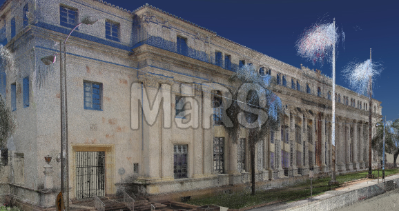
We deliver detailed Point Cloud to AutoCAD or Scan to CAD Conversion services in countries like the USA, UK, UAE, Saudi Arabia, Canada, Australia, India, Germany, Switzerland, Sweden, and over 20 more. In the architecture, engineering, and construction industries, the ability to translate point cloud data into 2D drawings has become an essential step for accurate project execution. Point clouds are created using laser scanning or photos and capture the shape of real spaces, helping us document existing conditions, renovations, and complex designs accurately.

MaRS Trans USA specializes in converting raw point cloud data into clear, accurate 2D CAD drawings. We support a wide range of point cloud formats, including RCS/RCP, E57, LAS, LGS, XYZ, PCG, and PTX. Our expert team of CAD modellers meticulously analyzes point cloud files and produces 2D CAD drawings, ensuring smooth integration into your workflows and accelerating project timelines.

3d-bim-modeling-services

Our Expertise in Point Cloud to 2D CAD Drawings

we specialize in converting point cloud data into accurate 2D CAD drawings, delivering precision and clarity for projects of all sizes. With a wealth of experience serving clients across multiple industries, we ensure every project receives the highest level of attention to detail.

  • Point Cloud to 2D CAD Drawing Transformation: We take raw point cloud data from laser scans and turn it into accurate 2D CAD drawings. Our team uses the best tools and methods to make sure every drawing exactly matches the scanned site, ready to be used in bigger project plans.
  • Accurate Measurements and Drawing Detailing: Using point cloud data, we generate precise 2D CAD drawings that reflect exact measurements and critical features. These drawings include plans, sections, and elevations, offering a reliable base for design, planning, or construction work.
  • Integrating Existing Infrastructure into Drawings: Our team specializes in incorporating walls, beams, columns, and utilities into detailed 2D CAD drawings. These precise visuals are vital for renovation, expansion, or any project involving modifications to current structures.
  • Data Calibration for Precise Measurements: We calibrate and align scanned point data to ensure the highest level of accuracy in our 2D CAD drawings. By focusing on precise measurements, we eliminate discrepancies and provide reliable data for your projects, from construction to design.
  • High-Quality CAD Deliverables: Using popular CAD formats like .DWG, .DXF, and .DGN, we create high-quality 2D CAD drawings that meet industry standards. These drawings are customized to fit your project needs and can be seamlessly integrated into your design or planning processes.
  • Expertise with Leading Software Tools: Our team uses a variety of advanced software platforms like AutoCAD and Revit to turn point cloud data into both 2D and 3D models. With these tools, we can offer flexible and accurate CAD deliverables that streamline your workflow and enhance project outcomes.

Benefits of our Point Cloud to 2D CAD Drawings Services

  • Accurate as-built documentation
  • Early detection of design issues
  • Detailed representation of existing conditions
  • Reduced construction errors and risks
  • Faster planning and design stages
  • Simplified renovation and remodeling
  • Precise structural measurements
  • Streamlined plumbing system installation
  • Better management of utilities
  • Enhanced safety with accurate data
  • Minimized costly mistakes on-site
  • Clear visualization of water systems
  • Easier planning for water line upgrades
  • Improved integration of MEP systems
  • Precise layout for drainage systems
  • Better project scheduling and budgeting
  • Effective collaboration with architects
  • Simplified building expansion planning
  • Accurate design for new water infrastructure
  • Better facility maintenance planning
  • Clear mapping of HVAC systems
  • Time savings with reduced measurements
  • Optimized use of space for water systems
  • Organized documentation management
  • Quick data conversion for project efficiency
  • Seamless integration with other systems
  • Enhanced Collaboration
  • Seamless BIM Integration
  • Improved workflow efficiency
  • Reduction of rework and errors
  • Easier coordination across different teams
  • Cost-effective conversion of scan data
  • Faster delivery of project milestones

Our Specialty in Point Cloud to 2D CAD Drawings

3D Scan to BIM Modeling for Commercial and Residential Building

Construction Buildings

Point Cloud to BIM modeling simplifies various construction processes, including renovation and remodeling projects, by offering the most precise method of collecting building details. It translates these details into actionable execution seamlessly, ensuring that both commercial and residential buildings maintain top-notch accuracy and quality throughout the entire construction process.

Scan to BIM Modeling for historic building preservation

Historical Buildings

Historic buildings with intricate architecture challenge modern restoration. Scan to BIM captures detailed design data, ensuring preservation of historic character while enabling updates. This method supports accurate restoration to original states, blending tradition with technology and helping guide modifications throughout the project with precision and respect for the building's legacy.

Point Cloud to BIM Modeling for Large Scale Projects

Large-Scale and Small-Scale Projects

For large-scale projects like airports and public infrastructure, scan to BIM is key for collecting data for planning and execution. It captures location-specific details and needed changes for accurate modeling. For smaller projects, it also provides reliable data that streamlines construction, helping manage even complex aspects of smaller spaces.

Our Key Sectors

  • Civil Engineering
  • Structural Engineering
  • Infrastructure Development
  • Surveying and Mapping
  • Real Estate Development
  • Infrastructure
  • Urban Planning
  • Landscape Architecture
  • Historic Preservation
  • Industrial Design
  • Shipbuilding
  • Oil and Gas Industry
  • Smart Cities and IoT Planning
  • Geospatial and GIS Mapping
  • Military and Defense
  • Retail and Commercial Development
  • Aerospace Engineering
  • Heritage Conservation
  • Road and Highway Construction
  • Bridge and Tunnel Construction
  • Site Development and Earthworks
  • High-Rise and Skyscraper Construction
  • Utility Infrastructure
Point Cloud to 2D CAD Drawings for Architectural Design   |   Point Cloud to 2D CAD Drawings for Structural Engineering   |   Point Cloud to 2D CAD Drawings for Facilities Management   |   Point Cloud to 2D CAD Drawings for Urban Planning   |   Point Cloud to 2D CAD Drawings for Civil Engineering   |   Point Cloud to 2D CAD Drawings for Interior Design   |   Point Cloud to 2D CAD Drawings for Historical Conservation   |   Point Cloud to 2D CAD Drawings for Manufacturing & Prefabrication   |   Point Cloud to 2D CAD Drawings for Commercial Developments   |   Point Cloud to 2D CAD Drawings for Real Estate Development   |   Point Cloud to 2D CAD Drawings for Hospitals   |   Point Cloud to 2D CAD Drawings for Educational Facilities   |   Point Cloud to 2D CAD Drawings for Industrial Plants   |   Point Cloud to 2D CAD Drawings for Airport Infrastructure   |   Point Cloud to 2D CAD Drawings for Retail Developments   |   Point Cloud to 2D CAD Drawings for Warehouse Management   |   Point Cloud to 2D CAD Drawings for Government Buildings   |   Point Cloud to 2D CAD Drawings for Site and Land Surveys   |   Point Cloud to 2D CAD Drawings for Event Management Venues

What Makes Our Point Cloud to 2D CAD Drawings Solutions Exceptional?

Prompt Quotes

Point Cloud to CAD Services

Our point cloud to CAD services offer a wide range of solutions designed to meet the unique requirements of your project. We specialize in converting raw scan data into 2D and 3D CAD drawings, allowing you to visualize and refine your designs with accuracy. Whether you're working with LiDAR or other scanning technologies, our team has the expertise to transform complex point cloud data into usable CAD models for various applications.

Value Driven Pricing

2D and 3D CAD Conversions

We provide seamless conversions of LiDAR scans into both 2D and 3D CAD drawings, offering detailed representations of your scanned environment. Our team produces precise floor plans, elevations, and sections to help streamline design and construction workflows. These high-quality CAD drawings serve as the foundation for further project development, ensuring that every dimension, feature, and detail is captured accurately.

Software Expertise

Architectural and MEP Modeling

Our services extend to creating architectural models and MEP drawings from point cloud data. We convert raw scan information into architectural floor plans, 3D models, and system layouts that align with your design specifications. Whether you’re working on new constructions, renovations, or infrastructure upgrades, we ensure the accurate placement and alignment of key building elements, helping to prevent issues and optimize coordination.

Global Collaboration

CAD Modeling for Facility Management

We offer CAD modeling solutions for facility management. Our team helps you convert scanned data into detailed, actionable models that can be used for ongoing maintenance, renovation, and future planning. These CAD models provide a solid foundation for asset management, space planning, and facility operations, helping you keep track of critical infrastructure elements and making it easier to plan for long-term sustainability.

Our Point Cloud to 2D CAD Drawings Packages

Architectural Base Model Includes:

Floor plans, Elevations, Sections, Roof layouts, Wall layouts, Doors and windows placement, Structural elements (beams, columns, load-bearing walls), Ceiling heights and levels, Staircases and ramps, Interior layout dimensions, Wall finishes, Floor finishes, Roof details.

Architectural Add-on includes:

Interior moldings and trims, Baseboards, Wainscoting, Crown molding, Staircase details (railings, treads, risers), Window and door schedules, Wall panels and partitions, Ceiling grid systems, Decorative ceiling treatments, Shelving and cabinetry layouts, Signage and room identification, Furniture placement.

Site Add-on includes:

Site plan layout, Parking areas and driveways, Walkways and paths, Retaining walls, Outdoor features (gardens, water features), Drainage systems (stormwater, sewer), Landscape elements (trees, shrubs), Signage (site navigation), Outdoor lighting placement.

Mechanical Base Model includes:

HVAC system layouts (ducts, vents, grilles), Mechanical rooms and equipment locations, Plumbing lines (water and waste systems), Electrical distribution systems, Electrical panels and circuit placements, Power and lighting circuits, Air handling units and chillers, Exhaust systems and ventilation details.

Mechanical Add-on includes:

Detailed HVAC system layouts (including units and ducting), Plumbing and fixture locations, Electrical conduit and cable routes, Emergency lighting placement, Grounding and earthing systems, Energy-saving systems (e.g., heat recovery), Special equipment placements (e.g., chillers, pumps).

Electrical Add-on includes:

Circuit breakers, Electrical panels, Switches, Receptacles, Wiring systems, Transformers, Generators, Surge protection devices, Grounding systems, Emergency lighting, Exit signs, UPS systems, Lighting controls, Power distribution units, Electric vehicle charging stations.

Our Process for Point Cloud to 2D CAD Drawings

01

Importing and Aligning Data

We import the point cloud data into CAD software like AutoCAD and align multiple scan files to create a unified model.

02

Cleaning the Data

We remove irrelevant points to focus on key geometry, ensuring the data is accurate for conversion.

03

Converting to 2D CAD Geometry

Using commands like "Point Cloud Surface," we convert the point cloud data into 2D CAD geometry, such as floor plans and elevations.

04

Refining and Annotating

We refine the CAD model by adding dimensions, annotations, and layers for clarity and precision.

05

Finalizing and Delivering Files

The finalized 2D CAD drawings are saved in the required format (e.g., DWG) and delivered to the client after feedback is reviewed.

Best Scan to BIM Company in USA

FAQs on Our Point Cloud to 2D CAD Drawings Services

We provide precise and accurate Point Cloud to 2D CAD conversion services that help you turn complex scanned data into clear, actionable 2D CAD drawings. By reducing manual drafting, we save you time, minimize errors, and ensure your project stays on track with well-documented, high-quality designs.

Our team at MaRS Trans USA uses advanced tools and proven techniques to deliver highly accurate 2D CAD drawings from point cloud data. We ensure seamless integration with your existing workflows, offering timely and precise results tailored to your project's specific needs.

Absolutely! Whether it's a small residential renovation or a large industrial complex, we have the expertise and resources to handle projects of any scale. Our services are flexible and customized to meet your unique project requirements.

We utilize the latest technologies and a thorough quality control process to ensure that every 2D CAD drawing accurately represents the original point cloud data. Our team meticulously verifies each conversion, making adjustments where necessary to guarantee precision and reliability.

We deliver your Point Cloud to 2D CAD conversion in the file formats that best suit your needs, including DWG, DXF, and PDF. These formats are compatible with most CAD systems and ensure easy integration into your project workflows.

Getting started is easy! Simply contact our team, share your project details, and we’ll work with you to develop a customized plan. We’ll guide you through every step of the process, ensuring a smooth and efficient transition from point cloud data to 2D CAD drawings, tailored to your exact requirements.

We provide Point Cloud to 2D CAD conversion services to a wide range of industries, including construction, architecture, engineering, manufacturing, and historical preservation. Our services are adaptable to the unique needs of each sector, ensuring accurate and efficient results for any type of project.

The timeline for your project depends on its size and complexity. However, we prioritize delivering efficient and high-quality results. We’ll provide you with an estimated timeline based on your specific project needs and ensure timely delivery without compromising accuracy.

Related Projects

Explore All Projects

Looking for an adequate BIM solution for your next project?

Contact us today for free consultation or more information.

Get In Touch